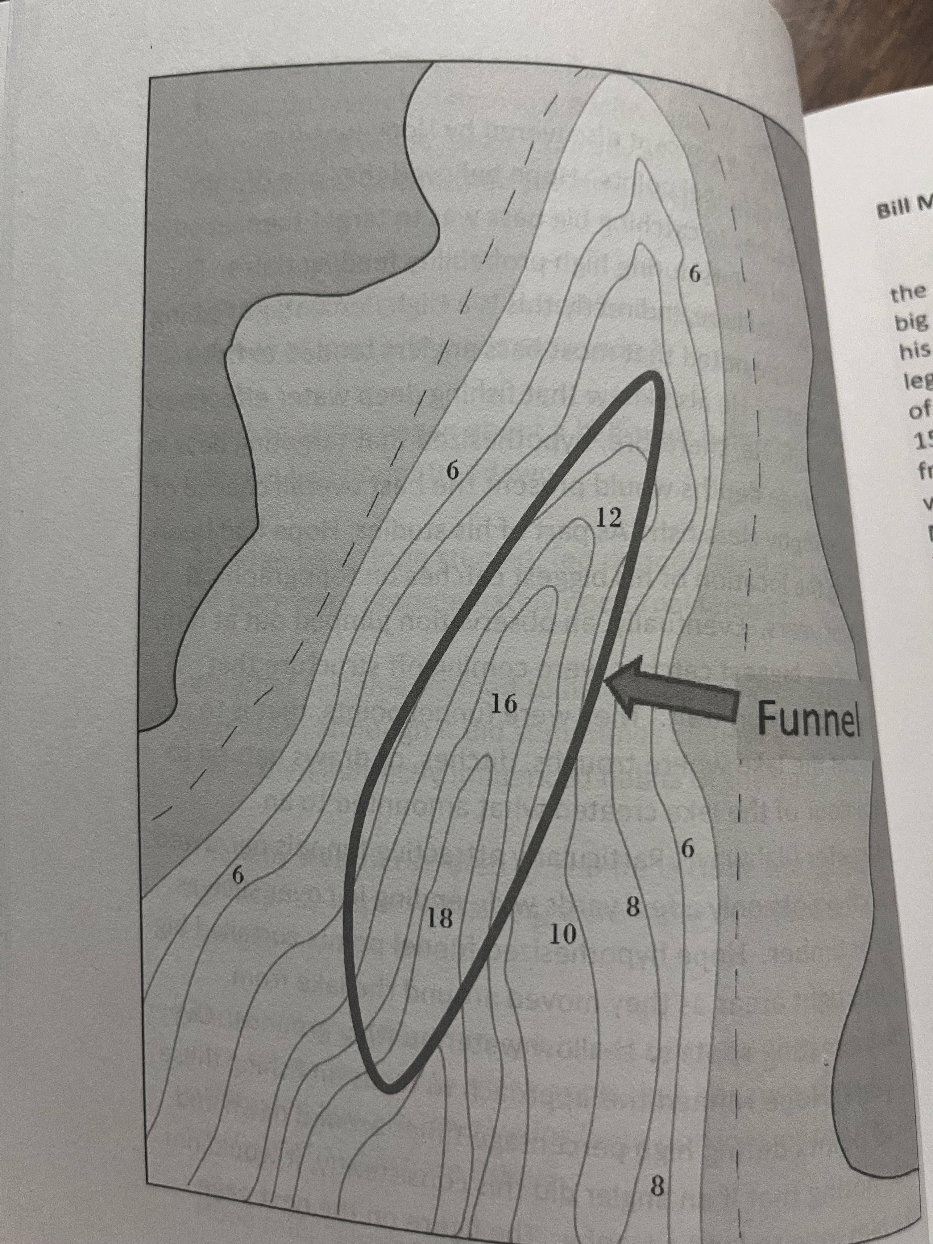
new to topo maps, can someone please explain how this is a funnel? and how to visualize from an underwater perspective?
new to topo maps, can someone please explain how this is a funnel? and how to visualize from an underwater perspective?
Posted by FabledWaters
6 Comments
Ottomatica on
If fish are swimming at say 12 feet from both sides and heading NNE it would funnel them in the area. This would look like a small canyon.
If you inverted it and put it above water with trees of the same height as depth, it would look like a point. For deer hunters, this can function as a funnel when you drive deer to the end of the point. You position your shooter at the end of the point as the deer would follow the tree line until they come out the end in a predictable fashion.
jhe888 on
It looks like a long hole to me. It may funnel fish to the deeper part of the hole along the long axis as the gradient is more gentle
GeoHog713 on
The parts circled are like the axis of a canyon.
Chad_sc864 on
I dont call it a funnel, most people call them ditches. Its a dang fish highway in certain times of the year. Imagine a gently sloping bank, then a deep trench in the center that flattens back up towards the back. If your new to these style of maps, one of the biggest take aways is how close the lines are together. Lines super close= very steep bank.
DJSureal on
I tend to call these underwater points.
DJSureal on
Its like an underwater canyon with a gradual depth change from 12 to 18 ft and climb to 6 ft on the sides. Its a choke point for bait fish and allows the bass to move up and down in the water column without using much energy.

6 Comments
If fish are swimming at say 12 feet from both sides and heading NNE it would funnel them in the area. This would look like a small canyon.
If you inverted it and put it above water with trees of the same height as depth, it would look like a point. For deer hunters, this can function as a funnel when you drive deer to the end of the point. You position your shooter at the end of the point as the deer would follow the tree line until they come out the end in a predictable fashion.
It looks like a long hole to me. It may funnel fish to the deeper part of the hole along the long axis as the gradient is more gentle
The parts circled are like the axis of a canyon.
I dont call it a funnel, most people call them ditches. Its a dang fish highway in certain times of the year. Imagine a gently sloping bank, then a deep trench in the center that flattens back up towards the back. If your new to these style of maps, one of the biggest take aways is how close the lines are together. Lines super close= very steep bank.
I tend to call these underwater points.
Its like an underwater canyon with a gradual depth change from 12 to 18 ft and climb to 6 ft on the sides. Its a choke point for bait fish and allows the bass to move up and down in the water column without using much energy.